
Question
(a)
I) What type of map is Kijabe?
II) Give the position of Kijabe railway station by latitude and Longitude.
III) Identify two human made features at grid square 2693.
(b)
I) What is the four figure grid reference of Kagwe Carbacid plant?
II) Citing evidence from the map, give three social services offered in the area
covered by the map.
(c) Describe the distribution of natural vegetation in the area covered by the map.
(d)
I) Using a vertical scale of 1cm to represent 100 metres, draw an accurate cross
section along northing 00 from easting 24 to easting 30.
II) On the cross section, mark and name:
- Kijabe Hill
- A railway line
- A district boundary
- A river valley
III) Calculate the vertical exaggeration of the cross section.
Answer
(a)
I) Topographical
II) (0 0 55' South, 36 035' East)
OR
Latitude 0 0 55' South.
Longitude 36 035' East.
III)
- Telephone line
- Powerline
- A permanent building
- A major fence/hedge/wall
- A main track road/motorable road.
(b)
I) 3796
II)
- Education due to presence of many schools
- Medical services due to presence of Kijabe hospital and dispensaries near Kereita and at Kinale
- Religious services due to presence of a church at Kambaa.
- There is a bamboo forest east of Kinari in the northern parts.
- A large section of the eastern parts are covered by Wakagwe forest.
- A section of Nyamweru forest occurs on the south western parts/near Kambaa.
- There is a thicket in the southern parts.
- Most western parts have scrub vegetation especially along Ewaso Kedong Valley.
- There is a woodland around the hot springs at grid square 3297.
- A mixture of scattered trees and scrub is evident around Kinari in the Northern parts.
(d) I)
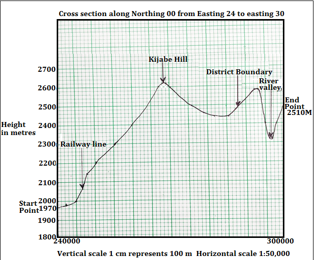
II) II) On the cross section, mark and name:
- Kijabe Hill
- A railway line
- A district boundary
- A river valley
III) VE = Vertical scale/Horizontal scale
= 1cm represents 100M/1:50,000
= 1:10,1000/1:50,000
= (1/10,000) x (50,000/1)
= 5 or 5 times