
Question
The table below shows land use in Nairobi county in 2016. Use it to answer the questions that follow.
(i) Use the above data to draw a divided rectangle. The length of the rectangle should be 10 cm.
(ii) Analyze and interpret the drawn divided rectangle.
(iii) State three advantages of using divided rectangles in the presentation of statistical data.
| LAND USE | AREA IN '000Km2 |
|---|---|
| Settlement | 110 |
| Grass | 30 |
| Horticulture | 50 |
| Forest | 10 |
| TOTAL | 200 |
(i) Use the above data to draw a divided rectangle. The length of the rectangle should be 10 cm.
(ii) Analyze and interpret the drawn divided rectangle.
(iii) State three advantages of using divided rectangles in the presentation of statistical data.
Answer
(i)
Settlement - (110/200) x 10 = 5.5cm
Grass - (30/200) x 10 = 1.5cm
Horticulture - (50/200) x 10 = 2.5cm
Forest - (10/200) x 10 = 0.5cm
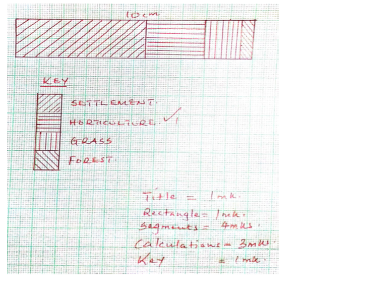
(ii)- Settlement covered more than half of Nairobi area in 2016.
- The second largest area was covered by horticultural farming.
- Forest covered the least area.
(iii) - Comparison of variables can be made with ease.
- A wide range of data can be represented.
- Easy to read because of the descending order of the arrangement.
- Gives a clear visual impression of individual components.
- Easy to draw.
- Covers less space.
Grass - (30/200) x 10 = 1.5cm
Horticulture - (50/200) x 10 = 2.5cm
Forest - (10/200) x 10 = 0.5cm
(ii)- Settlement covered more than half of Nairobi area in 2016.
- The second largest area was covered by horticultural farming.
- Forest covered the least area.
(iii) - Comparison of variables can be made with ease.
- A wide range of data can be represented.
- Easy to read because of the descending order of the arrangement.
- Gives a clear visual impression of individual components.
- Easy to draw.
- Covers less space.