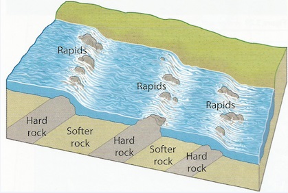
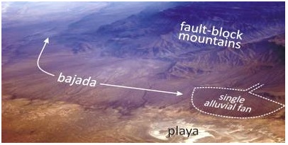
a) Alluvial Fans and Bajadas
- Fan shaped deposits of alluvium.
Formation
a. The river flowing through a narrow channel enters a plain from a higher ground and suddenly spreads out.
b. There is a sudden loss of velocity causing the river to scatter alluvium all around to form an alluvial fan.
c. Alluvial fans merge to form a continuous feature called bajada or piedmont fan.
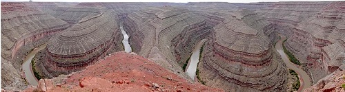
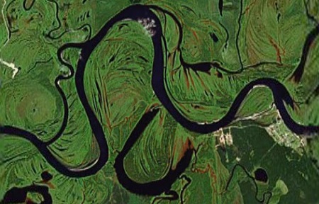
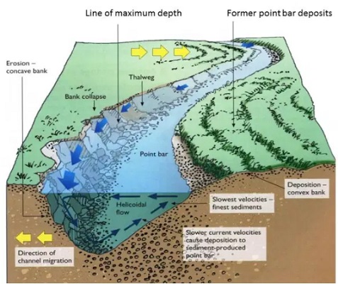
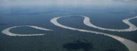
b) Meanders and Oxbow Lakes
- Meanders are loop-like bends in a rivers course.
- Oxbow lake is a horse shoe shaped section of a former river.
Formation
a. In mature stage river flows sluggishly due to reduced gradient.
b. It meets an obstacle and flows around it.
c. Erosion is greater on the outer bank and deposition on the inner bank causing the river to form loop like
bends.
d. Erosion continues on the outer bank (bluff) narrowing the land between the two outer banks forming a
pronounced meander e.g. on rivers Yala, Nzoia and Tana
e. During the floods when the river has more energy it cuts across the narrow land.
f. The former bends are cut off by deposition to form an oxbow lake e.g. Kanyaboli on R.Yala and Shakababo on R.Tana.
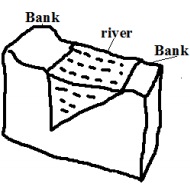
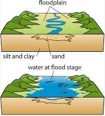
c) Flood Plains
- Wide gently sloping plain of alluvium on the floor of a river valley.
Formation
a. A river meanders.
b. There is erosion on outer bank and deposition on the inner bank.
c. The process continues and layers of alluvium deposited on inner bank join to form a plain e.g. Nzoia and
Yala flood plains.
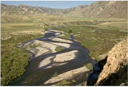
d) River Braids
Net work of diverging and converging channels along a rivers course
Factors favouring formation of braids
a) River must be carrying large load.
b) Reduced gradient on the section.
c) Reduced amount of water such as in dry season or arid conditions.
d) Presence of obstacles such as rock out crops.
Formation
a. River flows sluggishly due to low gradient.
b. Deposits of alluvium are laid on river bed.
c. The deposits raise the river bed causing the channel to be subdivided into channels or distributaries.
e) Natural Levees
- Raised river banks which are made of alluvial materials
Formation
a. River floods and spills over its banks.
b. Deposition of coarse materials near the banks and fine materials are carried further on the flood plain.
c. Coarse materials accumulate raising the banks above the general level of the flood plain
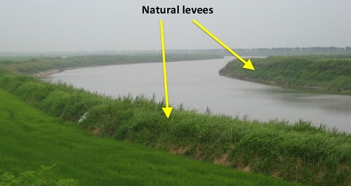
Effects of Levee Formation
a) Creation of differed tributaries and confluences.
Differed tributary: Tributary blocked from joining the main river by levees.
Differed confluence: New point where the differed tributary joins the main river downstream.
b) Destructive flooding.
i. Due to the river bursting its banks during the flood season due to the bed being raised above the general
level of the flood plain.
ii. Due to differed tributaries flowing into the flood plains.
iii. Because the river channel has become narrower and shallower due to deposited alluvium.
f) Estuaries
- Broad channel at the mouth of a river where the river enters the ocean as a whole.
- Some are deep and narrow because sediments are carried away by ocean currents while others are wide
and shallow due to sediments covered by water e.g. on R. Congo and Gabon.
g) Deltas
- Low lying tract of alluvial deposits formed at the rivers mouth
Ideal Conditions for Formation of A Delta At A Rivers Mouth
1. Large load such as from a large catchment area where erosion is taking place actively.
2. The rivers course to be free from obstacles such as swamps so as not to filter sediments before they reach
the mouth.
3. Low speed at the point where the river is entering a sea or lake for deposition to take place.
4. The rate of deposition should be higher than the rate of erosion by sea or lake currents.
How a Delta Forms
a. The speed of the river is checked by sea or lake.
b. Heavy load is first deposited.
c. Lighter load is carried further into the sea causing that part of the sea to become shallower.
d. The part is colonised by plants making it swampy but firmer.
e. Plants trap more alluvium making the delta to grow in height.
f. The river builds levees making it narrower.
h. The river burst its banks and small channels branch off the main river and carries water into the sea or lake
(distributaries).
Types of Deltas
1. Marine: Type formed at sea.
2. Lacustrine: at a lake.
3. Inland Delta: Deltas which form along a rivers course before it reaches the lake or sea.
a. The velocity of the river is checked on entering a relatively flat swampy land.
b. The river builds up levees.
c. The river bursts banks forming distributaries.
d. Alluvial deposits are spread over vast areas when river floods e.g. Niger and Okavango deltas.
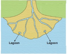
4. Arcuate Delta
A delta with a convex shoreline on the seaward end due to strong currents spreading materials over a wide
area on seaward side.
- Has many distributaries e.g. Tana and Rufiji deltas.
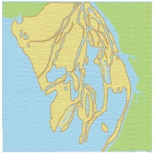
 5. Birds Foot Delta
- Type of a delta with a pattern resembling the foot of a bird.
- Has few distributaries.
- Formed on a river carrying large quantities of fine alluvium into water where there is low wave energy e.g.
Omo and Mississippi deltas.
 6. Estuarine Delta
- Delta which has formed on an estuary.
Formation
a. The rivers load is deposited on the estuary when the speed is checked by sea.
b. The river cuts across in a single channel that may be bordered by levees e.g. on R.Volta in Ghana and on R. Zambezi.