Esoma-KE Logo
Change Class  |  Change Subject

Climate | Geography Form Two

Climate

  Change Class FORM TWO
Select Subject  |  Geography
  Change Topic

Guest Account

Hello Guest, Create an Account or Login to save your progress and get unlimited access to more notes, revision exercises and answers.

Feeling Ready?

Attempt Form Two Geography Questions
Guest Account
Hello guest, kindly login to access unlimited study notes and revision questions.

Create an account / login to help track your progress and unlock more features including additional notes, rapid quizzes, revision questions, virtual library, and the new Esoma Classroom

Climate

Climate is the average weather conditions of a given place over a long period of time usually 30 - 35 years.

Factors Influencing Climate

Latitude
  • It influences temperature whereby low latitudes have high temperature and high latitudes have low temperature due to the angle at which the sun rays strike the earth and the distance travelled by the suns rays.
  • It also influences rainfall whereby places in the equator receive rainfall in two seasons when the sun is overhead there while northern and southern tropical areas receive rainfall when the position of the sun is overhead in those areas.
Inter-Tropical Convergence Zone
It's a low pressure belt around equator where trade winds converge.
It influences rainfall in the following ways:
  • Places further from equator experience one rainy season when the sun is overhead and a long dry season when the sun is in the S. hemisphere.
  • Regions near equator have 2 seasons of heavy rainfall because they experience passage of ITCZ twice.
Altitude
  • It influences temperature whereby at low altitude temperature is high while at high altitude its lower due to the thickness of atmosphere determining the number of particles to store heat and distance from space where terrestrial radiation is lost.
  • It also influences rainfall whereby mountains on the path of rain winds receive Orographic rainfall and the windward slopes receive heavier rainfall than leeward slopes.
Distance from the Sea
  • It influences temperature whereby places in temperate regions near the sea experience low temperature during summer onshore winds blowing over cold ocean water and taking the cooling influence on adjacent land because the water is heated at a slower rate than land
  • Places near the sea also experience higher temperatures during the winter or cool season due to sea breezes carrying warmer air to the land because water loses heat at a slower rate than land.
  • Temperatures in the interior of continents tend to be high in summer and very low in winter due to lack of marine influence.
  • It also influences rainfall whereby coastal regions receive a lot of rain when the winds are onshore and the continental interiors receive less rain mainly in summer because onshore winds will have dropped most of moisture along the way.
Ocean Currents
  • It influences temperature whereby coasts which are washed by warm ocean currents are warmer while those washed by cold ocean currents are cooler due to the onshore winds being either warmed or cooled and then taking the warmth or coolness to the land.
  • It influences rainfall whereby coasts washed by warm ocean currents experience heavy rainfall when moist onshore winds are warmed by the current and made to hold on to moisture which they release on reaching the land.
  • The coasts washed by cold ocean currents on the other hand experience low rainfall as a result of moist winds being cooled and moisture in them condensed resulting in rain falling over the ocean thereby bringing little or no rain to the coastal areas. This is the cause of western margin deserts e.g. Kalahari and Namib deserts.
Aspect
- Direction of slope in relation to sunlight and the rain bearing winds. Its effect on temperature is more pronounced in the northern and southern hemisphere.
  • In the N and S hemispheres the slopes facing sun are warmer while those facing away are cooler.
  • The slopes in the direction of rain winds i.e. the windward slopes receive heavier relief rainfall than the leeward side.
Winds and Air Masses
Wind blowing from a warm region warms the region its passing over and if blowing from a cool region cools the region it's passing over since wind is a medium of transfer of heat.
  • Sea breezes take cooling influence on land during hot afternoons.
  • Katabatic winds cause low night temperatures on valleys and foot of mountains.
  • Fohn and Chinook which are descending dry winds take dryness to the leeward sides of Alps and Rockies.
Winds influence rainfall in the following ways:
  • Anabatic winds cause afternoon showers on mountainous regions.
  • Moisture laden winds cause heavy rainfall.
  • Persistent dry winds cause desert like conditions in the area they pass over e.g. Harmattan winds from Sahara which blow over W. Africa.
  • Regions around large water bodies experience high rainfall because of the effect of land breezes.
Configuration of Coastline
Coastal regions across the path of moisture laden winds receive higher rainfall because winds deposit moisture on land e.g. Mombasa while those lying parallel to the path of those winds receive less rainfall because moisture is deposited on the sea e.g. Lamu.
Forests
Forested areas experience a micro climate whereby:
  • Temperature is lower due to shades of trees reducing solar insolation reaching the ground.
  • Rainfall is heavier due to high rate of evapotranspiration and friction between trees and rain bearing winds.
Human Activities
  • Man has caused deforestation in the process of creating room for settlement and agriculture which has caused drop in rainfall amounts leading to semi-arid conditions.
  • Man has constructed dams across rivers and done afforestation which has caused semi-arid regions to become wetland.
  • Gases especially co2 emitted from burning fossil fuels and chlorofluorocarbons layer cause global warming through the green house effect and destruction of ozone layer respectively.

The Climatic Regions of Kenya

Climatic Regions in Kenya-Geography Form Two
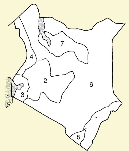
Climatic Regions in Kenya (Image: Courtesy)

KEY
1. Modified Equatorial Climate of the Coast
2. modified Tropical Climate of the Highlands
3. Modified Equatorial Climate of the Lake Basin
4. Modified Equatorial Climate of the North Western Margin
5. Tropical climate of Narok and Southern coastal Kwale areas
6. Tropical semi-desert climate of the central and northern areas
7. Desert climate of central northern areas.

Modified Equatorial Climate

Experienced along the coast and along the coast from Somali-Tanzanian border and L. Victoria basin regions around the lake.

Along the Coast
Characteristics
  • High temperatures throughout the year mean annual about 27°c.
  • Small mean annual range of temperature about 4°c.
  • Hottest months are December and January.
  • Experiences rainfall throughout the year/ no real dry season.
  • Double maxima rainfall regime (2 rain seasons) in May and October.
  • High humidity due to high temperature causing high rates of evaporation and nearness to the sea.
L. Victoria Basin
Characteristics
  • Temperature is lower than the truly equatorial climate due to modifying influence of the lake (mean annual range between 22-26°c).
  • There are no real dry months.
  • Heavy rainfall ranging from 1000-600mm.
  • Double maxima rainfall regime.
  • Receives convectional type of rainfall which falls mainly in the afternoons.
  • High relative humidity due to high temperature and nearness to the lake which is a source of moisture.

Modified Tropical Climate

Experienced in central highlands E and W of R. Valley.
Characteristics
  • Mean annual temperatures averages between 17 - 24°c.
  • Lower warmer slopes and cooler higher slopes due to modification by altitude.
  • Receives rainfall throughout the year (1000mm - 2000mm).
  • Receives Orographic rainfall caused by S.E Trade Winds.
  • Double maxima rainfall regime in eastern highlands and single maximum in the W. highlands.
  • Humidity is moderate.

Tropical Continental/desert Climate

Experienced in about ½ of Kenya in most of North, North Eastern, most of Eastern and Southern Kenya. Characteristics
  • High temperatures throughout the year with mean between22 and 27°c.
  • Generally dry with less than 500mm of unreliable rainfall.
  • Large diurnal range of temperature.
  • The skies are generally clear.
  • Low humidity.
  • Temperature has been modified by relief in some areas e.g. Voi - 25°c and Garissa - 28.5°c.

Tropical Climate

Experienced in Narok, S. Taita and Kwale region.
Characteristics
  • High temperatures (mean annual temp-16.5°c).
  • Temperature is modified by relief in some areas e.g. Loita, Taita and Narok which has made the place suitable for human habitation.
  • Generally low rainfall amounts.
  • Rain falls in one season.
  • A long dry season lasting up to 6 months.

Tropical Northern Climate

Experienced in a small area in the N. W part of Kenya bordering Uganda.
Characteristics
  • High average temperatures.
  • Temperatures are modified in some places by altitude.
  • Low mean annual rainfall of about 850mm.
  • Rain falls mainly in June and September.
  • Experiences a long dry season of up to 6 months.

Desert Climate

Experienced in central northern Kenya where there are pure deserts such as Chalbi, Karoli and Kaisut deserts.
Characteristics
  • Temperatures are very high throughout the year averaging 30°c due to cloudless skies.
  • Very low rainfall of less than 250mm per year.
  • Characterised by diverging or descending winds which don't bring any rain.
  • Night temperatures are extremely low.
  • Humidity is low.
  • Sandstorms are common occurrences

World Climatic Regions Classifications

1. Hot climates
2. Warm climates
3. Cool climates
4. Very cold climates
5. Mountain climates
6. Micro/local climates

 World Climatic Regions-Geography Form Two
World Climatic Regions (Image: Courtesy)

Hot/Tropical Climates

-Experienced within the tropical latitudes.
-Subdivided into:
(a) Equatorial climate
(b) Tropical monsoon climate
(c) Savannah climate/Sudan type
(d) Tropical desert climate
(e) Tropical marine climate

Equatorial climate

Experienced in the following areas:
(a) Amazon basin in S. America.
(b) Along west coast of Africa from guinea to Cote d' Ivoire.
(c) Southern part of Nigeria through Cameroon, Gabon, Central African Republic, Congo to Zaire.
(d) South East Asia in Malaysia, Indonesia and a stretch between Burma and Vietnam.
Characteristics
  • High temperatures throughout the year (between 24 - 27°c).
  • Temperature neither rises nor drops too low due to thick cloud cover all year round.
  • Heavy rainfall throughout the year (mean annual of about 2000mm).
  • Double maxima rainfall regime.
  • Experiences convectional rainfall in low lands and relief rainfall in areas of high relief.
  • High relative humidity of over 80% due to convergence of moist air masses and high evapotranspiration rates.
  • Low pressure all year round.
  • There are no seasons.

Tropical Monsoon Climate

It's found in the following areas:
(a) S.E Asia in parts of Pakistan, India, Bangladesh, S. china and Philippines.
(b) Along the northern coastal region of Australia.
Characteristics
  • High mean annual temperatures of about 28°c.
  • Seasonal reversal of winds.
  • Heavy rainfall when monsoon winds are onshore (600m - 1300mm).
  • Rain falls in a few months and the rest of the year is dry due to influence of latitude.
  • Low pressure in summer when winds blow onshore.
  • High pressure in summer when winds blow offshore.
  • Cloudy skies in summer and clear skies in winter.

Tropical Marine Climate

It's found on windward slopes of islands and coastal areas on the east of continents under the influence of South East Trade Winds in the following areas:
(a) Caribbean America in South Mexico through Guatemala, Nicaragua and Panama.
(b) Northern coast of South America.
(c) Caribbean islands of Cuba, Haiti and Jamaica.
(d) Coastlands of East Africa from Kenya, Tanzania through Mozambique and East Malagasy.
Characteristics
  • Summer temperatures are very high approximately 30°C.
  • High rainfall totals in summer when winds are onshore (1000-2000mm).
  • Orographic and convectional rainfall in summer.
  • Dry winters due to winds being offshore.
  • High humidity due to coastal location.
  • Experiences tropical cyclones towards end of hot season.
  • Winters are cool (about 21°c).

Tropical Continental/Savanna/ Sudan type

It is the largest natural climatic region in Africa.
It's found in the following areas:
(a) In Africa it extends from Senegal through Eastern Africa to the northern part of South Africa.
(b) Western Madagascar.
(c) A broad belt in North Australia.
(d) North West and South East of Amazon Basin called Llanos and Campos.
Characteristics
  • Higher temperatures of up to 32°in hot season.
  • Large diurnal range of temperature in dry season.
  • Convectional rainfall in summer averaging 765mm annually.
  • High humidity during the hot wet season.
  • Low humidity in cooler drier months.
  • Prevailing winds are mainly trade winds.
Types of deserts
  • Erg - Sandy deserts with large amounts of deposited sand.
  • Hamada - Rocky deserts made of bare surfaces.
  • Reg - Rocky deserts covered with angular pebbles, gravels and boulders.
  • Hot continental interior deserts found on the interior of continents on the leeward sides of high mountains e.g. Sahara and Arabian Desert.
  • Coastal deserts of western margins characterised by offshore trade winds and cold ocean currents e.g. Atacama of S. America, Namib in Namibia and Arizona in U.S.A.
  • Mid latitude deserts of continental interiors with high summer and low winter like Gobi in C. Asia.
  • Ice and snow deserts of polar lands like Greenland and Antarctica desert.

Tropical Desert Climate

Found on the western coasts of continents washed by cold ocean currents.
They are the following:
  1. Arabian Desert of the middle East
  2. Sahara, Kalahari and Namib deserts in Africa
  3. Atacama Desert in S. America
  4. Mohave and Colorado deserts of U.S.A. and Mexican deserts in North and Caribbean America
  5. Jordan, Syria, Iran, Iraq, Saudi Arabia, Israel and Afghanistan
  6. The great Australian desert in the greater western part of the continent
Characteristics
  • High temperatures during the day and very low temperatures during the night due to high terrestrial radiation.
  • Large diurnal range of temperature.
  • Clear/ cloudless skies.
  • Receives less than 250mm of rainfall annually
  • Rainfall is localised, short and torrential and accompanied by storms which cause flash floods.
  • Rain falls for a short period and the rest of the year or even several years are dry.
  • High wind velocity due to little frictional force.
  • Some areas experience temperatures below zero in winter with ice forming on the oasis.
  • Humidity is low and evaporation rate is high.
  • Sand storms are very common i.e. sand being blown through the air by the wind.

Warm Climates

They border tropical climates and they experience moderate temperatures lower than of tropical climates.
They are situated in the zone of divergence of trade winds and westerlies (subtropical high pressure belt).
Subdivided into:
  1. Warm temperate Western margin/Mediterranean Climate
  2. Warm Temperate Interior/continental Climate.
  3. Warm temperate Eastern marginal Climate.
  4. Warm temperate Deserts.

1. Warm temperate Western margin/Mediterranean Climate

- Also known as Mediterranean Climate.
- Found on the western margin or sides of continents in the following areas.
(a) Southern Europe and N. Africa in the lands bordering Mediterranean Sea.
(b) South Western tip of Africa around Cape Town.
(c) Central Chile in South America.
(d) South West and South Australia.
Characteristics
  • Hot summers with temperatures of about 21°c.
  • Mild winters with temperatures of about 10°c.
  • Characterised by hot and cold local winds called Mistral and Sirocco.
  • There is high sunshine duration and intensity in summer.
  • Experiences cyclonic rainfall in winter when westerlies are onshore.
  • Rainfall decreases inland.
  • Summers are dry due to trade winds blowing offshore.
  • There are distinct seasons i.e. summer, autumn, winter and spring.

2. Warm Temperate Interior/continental Climate.

Also called Steppe Type.
It's found in the interior of continents in the following areas (grasslands):
  1. Steppe Land of Russia
  2. Veldt of South Africa.
  3. Prairie lands of Canada and U.S.A.
  4. Pampas lands of Argentina.
  5. Downs of Australia.
Characteristics
  • Warm short temperatures between 18 - 21°c.
  • Long winters with extremely low temperatures due to continentality which can fall up to -20°c.
  • Precipitation is received all the year round.
  • Most rainfall is received in summer and snow precipitation in winter.
  • Rainfall is moderate with annual mean of 500mm.
  • Summer rainfall is caused by convection and depressions.
  • There is high humidity in summer.

3. Warm temperate Eastern marginal Climate.

Also known as China Type.
It's experienced on the eastern margins of continents in the following areas.
  1. South Eastern China and S. Japan.
  2. South Eastern Australia.
  3. Southern and South Eastern states of U.S.A.
  4. Southern America in Southern Brazil, Uruguay, Eastern Paraguay and coast of Argentina.
Characteristics
  • Hot summers with a mean annual of about 26°c.
  • Mild to cool winters due to marine influence and local winds (4-13°c).
  • Receives rainfall throughout the year (about 1000mm).experiences hurricanes and typhoons.
  • Convectional rainfall is common in summer.
  • Rainfall is moderate between 760 and1500mm

4. Warm temperate Deserts.

Also known as Mid-Latitude Desert climate.
It's experienced in the following areas:
  1. Nevada and Utah states of U.S.A.
  2. Pentagonia in S. America.
  3. Gobi Desert extensive desert area of southern Mongolia and northern China and the largest desert in Asia.
  4. Turkey, Turkmenistan, Uzbekistan and Kazakhstan.
Characteristics
  • High summer temperatures (27 to 37°c).
  • Cold winters as low as -7°c.
  • Very large diurnal and annual ranges of temperature.
  • Low and unreliable rainfall due to great distance from the sea about 250 mm annually.
  • Most rainfall falls in late winter or early spring.

Cool Climates

They differ from warm climates by having definite seasonal variations in temperature.
They are Subdivided into:
  1. Cool Temperate Western Margin
  2. Cool Temperate Continental Interior
  3. Cool Temperate Eastern Margin

Cool Temperate Western Margin Climate

- Also known as British Type.
- It's under coastal influence.
- Found in the following areas:
  1. British Isles (Island)
  2. Central and North West Europe
  3. North West U.S.A. and British Columbia in Canada.
  4. Southern Chile
  5. Tasmania in Australia
Characteristics
  • Warm summers (13 - 15°c).
  • Cool winters (2 - 7°c).
  • Small temperature range.
  • Well distributed rainfall throughout the year (760mm - 2000mm).
  • Cyclonic rainfall in the coastal lands and relief rainfall in mountainous areas.
  • High humidity in winters.
  • Long summer days with irregular thunderstorms.
  • Convergence of sub-tropical and polar air masses.
  • Onshore westerly winds are dominant.

Cool Temperate Continental Interior Climate

- Also called Siberian type.
- Found in the following areas:
(a) Alaska and most of Canada
(b) Eurasia covering Sweden, Finland, Poland, Germany, across former Soviet Union up to Kamchatka Peninsular in the east.
Characteristics
  • Warm summers with temperatures of about 18°c.
  • Generally short summers.
  • Extremely cold winter temperatures which go below 20°c.
  • Long winters with long nights.
  • Precipitation is mainly in form of snow during winter (annual precipitation 400mm - 500mm).
  • Convectional rainfall in summer is accompanied by thunderstorms.

Cool Temperate Western Margin Climate

It's also known as Laurentian Type.
It is found in the following areas:
  1. Northern U.S.A. and Southern Canada.
  2. Southern Argentina.
  3. North & South Korea, Northern China, Central Northern Japan and Eastern Siberia.
Characteristics
  • Long warm summers with temperatures of about 18°c.
  • Cold winters (-40 to 0°c).
  • Precipitation all year round (600mm - 1000mm).
  • Snow precipitation in winter.
  • High humidity in summer.

Cold Climates

- Also known as Polar Desert Climates or Arctic and Antarctic Climates.
- Found beyond Arctic Circle i.e. 66½°N and S of equator.
- Classified into Tundra and PolarClimates.

Tundra Climate

Areas with this climate include:
(a) Coast of North America bordering Arctic Ocean.
(b) Northern part of America from Alaska through Canada to Greenland.
(c) From North coast of Scandinavia to the North East of Russia.
(d) Baffin Island.
Characteristics
  • Short cool summers with average temperatures of about 10°c.
  • Long cold winters (-29 to -40°c).
  • Continuous days in winter and summer for several days.
  • Low annual precipitation of about 250mm.
  • Precipitation in form of rain and snow in winter.


Polar Climate

- It is experienced at the poles in the interior of Iceland, Green land and Antarctica.
Characteristics
  • Temperature is permanently below freezing point.
  • There is permanent snow cover and ice on the ground (permafrost).
  • Snow storms (blizzards) are common.
  • Continuous winter nights and summer days with exception of equinox when sun rises above horizon.

Mountain Climates

- It is experienced on high mountain ranges of the world.
- The following areas experience mountain climate;
  1. Mt. Kenya (5199)
  2. Mt. Ruwenzori (5109)
  3. Mt. Kilimanjaro (5895)
  4. Mt. Everest (8848)
  5. Atlas mountains in Africa
  6. Rockies of N. America
  7. Alps of Europe
  8. Himalayas in Asia
Characteristics
  • Temperature decreases with increasing altitude.
  • Temperature ranges from cool to cold.
  • Experiences Orographic rainfall.
  • Rainfall increases with altitude up to 3000mm and starts to decrease because air is cold and hence has poor capacity to hold moisture.
  • Windward slopes are wetter than leeward slopes.
  • Atmospheric pressure decreases with increasing altitude.
  • Local winds are common and blow up the slope during the day and down slope at night.
  • In temperate regions slopes facing the equator are warmer than those facing the poles.
  • Atlas mountains in Africa
  • Rockies of N. America
  • Alps of Europe
  • Himalayas in Asia

Hello Guest, Please help review these notes.    Why review

Your review has been successfully submitted.
Tell us what you think about the notes.

Submit Comment